Monday, December 1, 2014

Saving and Printing with Google Earth

It's one thing to document your families tells in Google Earth, but you need to be able to share it with others, and let that story be told. One way to do this without your family having to download their own Google Earth is to save and/or print images from your globe. This can all be done really easy and takes no time at all.

First zoom, rotate, tilt your globe to wherever, whatever your are wanting to share with your family. Then make sure you have what ever item you are wanting to share click ON in your MY PLACES folder or any other layers you want to share. Then all you have to do is go to File > Save > Save as Image. Then a pop up window will show up to select and name your image location and title. Then hit Save. You're done. You now can go to your file location and email to your friends and family like any other file.

More tips and things to know about printing Google Earth Images.
800x600
One thing you need to know is Google Earth only save at 72dpi. That is fixed, not much you can do about that. However your pixels is some what in your your control. Understand this first, with Google Earth Pro you get a lot more features. What I am talking about here is just the free version of Google Earth. The pixels you save your image at is somewhat in your control based on what the resolution of your screen is. I'm talking about going outside your Google Earth and looking at the resolution on your computer screen. If your computer screen is at 800x600 then you will have a lower resolution image than if you had your screen at 1024x768 or if you have a 4K screen you could have resolution about 3840 x 2160.
1024x768
Another thing about Google Earth that isn't the best because you lose information is, you can only have one balloon open at a time. So if you wanted to share info about multiple placemarkers you would only be able to display the info from the placemarkers balloon one at a time. There really isn't a work around for this but to add the missing info to the email, powerpoint, or printing in on the back of the image. ie. When I print a cemetery map, I will save the image and then print an info sheet on the back of the image that explains who, what, and when the placemarker is talking about.

Monday, June 9, 2014

10,000

Sorry I haven't posted in a while. Life just got really busy and I hadn't made time to write a post. Plus I am working towards tutorial videos not just screen shots of how I do stuff in Google Earth.

Well this blog just went over 10,000 views. I'm so excited, I didn't really comprehend how much other people would be interested in using Google Earth for their family research and storytelling. I promise I will have you a new post and video's soon with great tips to bringing your families story to life.

Thanks for your patience and understanding and will talk to you again soon.

Friday, March 28, 2014

Follow Your Family's Trail with Google Earth

I wanted to take a moment and thank GenealogyKC for allowing me to present at their conference this year. THANK YOU!!! I had a blast.

I ended up presenting 4 times, "Follow Your Family's Trail with Google Earth" the same material each time. Both Friday and Saturday I was in the small rooms just after lunch and then the large corner rooms for the last presentation of each day. I think it worked out great, my small class rooms didn't even have standing room avalible and the large rooms had every seat filled. I did not get a good head count but based on how many handouts I had left over I had ~183 people come watch the presentation. I really enjoyed myself presenting to this crowd. They were all very interactive, a few oohed and aahed, and some very good questions. I already have been asked to speak at another event this fall.

I hope you are all able find this site ok. Please feel free to drop me a line letting me know you came from Genenalogy KC. The blog is still young but if there is something you are needing help on let me know. My plan is to start adding video to this blog by the end of next month, so stay tuned.

Saturday, March 8, 2014

Overlay... Window to the Past

The next feature in the Google Earth toolbox is the Overlay. This is by far my favorite component to use for my family history, but it can also be the hardest to get correct. When I say overlay I am talking about taking an image and stretching it out over the globe like a magic blanket. I say magic because not only can you lay it out over an area, but you can turn on the terrain and make a three dimensional overlay, so if you are in a mountain range then you can still see those features instead of just a two dimensional picture. But wait there is more, just like Polygons you can adjust the transparency of the overlay to see what is underneath it too.
Stargard, Germany abt Oct 1944
Like I said earlier this is my most used tools, I have used overlay for flying routes, shipping lanes, and mostly used for plat maps. I love plat maps, it's like my little window to the past. You can take a plat map, stretch it over the township your ancestors lived in and then use that to figure out where things from the past laid in today's land. For instance, how many times have you see a old farm field turn into a subdivision. What I have done is place that plat map over the township and then used placemarkers to mark the Church, School, and Cemetery and then my polygons to mark the farm.
New York Township, Caldwell Co, MO 1930
You can find historic plat maps in a county atlas, or even googling for plot maps will lead you to all sorts of digital images of different counties and townships. Just make sure you watch your copyright laws. Just like all the other tools in google earth overlays too have a description box. This is a perfect place to put your source citation. Any notes you have on that particular overlay, even just jot something down about how you feel about that family discovery. Overlays I think are a key piece when sharing with family too. You all have heard the phrase “You can't be a prophet in your own land” (Luke 4:24), sometimes your family might find it hard to believe that your placemarker marks the location of Great Great Grandpa's farm house. That's where the overlay is nice because it is someone elses drawling of the land, who was alive at the time that your ancestor lived there, all you did was overlay it onto a modern map. The last thing I usually do with my plat map overlays and I have started adding to all my google earth tools, is adding a time stamp. Its by no means required it just adds another layer of realism to the story you are telling. The time stamp also allows you to have multiple files clicked ON while not having them became a huge pile of mess. The time stamps can be set to only show then activated by the time slider.

I hope you all will find a piece of your families history to overlay and create your own window to the past.  

Tuesday, February 18, 2014

Paths... Migration Up Hill Both Ways

Paths I will have to admit is one of the least used features of my google earth.  That being said its not without its uses, I just haven't ever made time to build a story out of it, but here is what I have used it for.

Paths are just lines, connecting point A to point B.  When I say lines, I don't mean just strait lines, you can drag, point, or click anywhere on your map to create your story.   Paths don't have to be tied to the ground either, you can have them float above the ground and/or even have it's lines extend to the ground.

So what stories can you tell with Paths?  I have seen and used them for many different things, from Civil War Marching routes, Grandpa's walk to school: you know... "up hill both ways" maybe you have a story of taking the wagon train west.  How about a old hunting trail, I have even used it to map a bombing mission route from England to Germany.

So here is what I have to show you today.  This is a path I have created showing the migration path of the family line of the Sutlief from my 11th Great grandfather Abraham Sutlief to my last move to Kansas City Missouri.  I am not going to go through the whole story with you but my family arrived in the Americas about 1623 and stayed in the Northeast until after the War of 1812.  Then after the early death of John Sutlief in 1835 one George Washington Sutlief decided to head to the Wild West of the Territory Kansas.  The Sutlief's stay in the Atchison, Kansas area for a few generations with a small stint in Ft Carson CO during Vietnam.  Then back to Atchison before moving to what I now call home Kansas City MO.

So what trail will you draw to document your family.  Will it be the summer vacation to grandma's house, or who your family crosses the Atlantic Ocean from Denmark to the great Mississippi River before taking the wagon train to Salt Lake City.  Leave a Comment and Share how you might create a Path in your own globe of Google Earth.

Monday, February 3, 2014

Polygon... Family Land

The Polygon feature of Google Earth is what I like to use when I find family land. Its a great feature where no matter what the shape of the land, you can outline the property with Polygon. It's a great way to highlight an area.

Just like placemarkers they have a Name and a Description, however their name field doesn't show text next to the Polygon like placemarkers do. Back to descriptions, you can use this to add pictures, maybe you have a picture of the old homestead or the original deed. I am usually using the Bureau of Land Management to find old land grants and I use the land description in the description box of the Polygon. Then when you create the Polygon you have the visual and when you click on it the balloon pops up with the raw description of the land. Color coding your family land can be very helpful as you are plotting family land. If your family is anything like mine, families that stayed in one place for very long, eventually end up marring the farmers daughter next door, and color coding will help you identify the different family groups. You may also be able to identify other locations to research, if a family owns all the land around but not a certain parcel of land, maybe you need to look into why they didn't purchase it or maybe you haven't discovered ownership yet.

The visualization benefit to using Google Earth and the Polygon feature is amazing. Helping identify migration patterns, the community church they worshiped at, or even the local burial ground. I have even had to do research into a old coal mine that was on the property, but wouldn't have known if I never took the land description and actually plotted the land out.

Family Land isn't the only thing I use Polygons for in Google Earth. I use them in cemeteries and military projects I have created too, really anything where I am trying to highlight an area of interest. The cool thing google has done is you aren't restricted to a two dimensional outline you can make it three dimensional also and either have it follow the shape of the terrain or even float above the area you are focused on.  Be on the look out for upcoming posts on how to make three dimensional Polygons.   

Thursday, January 16, 2014

Placemarkers... Cemeteries

Placemarkers are where it all began for me, if you would like to understand my why, you can check that out on one of my other blog posts In The Beginning, Why I'm Even Doing This? Part II.  To start out I'm not going to explain how placemarkers work, I am just going to show and tell how I am using them.  Hopefully this will motivate and give you ideas of how you can use placemarkers.

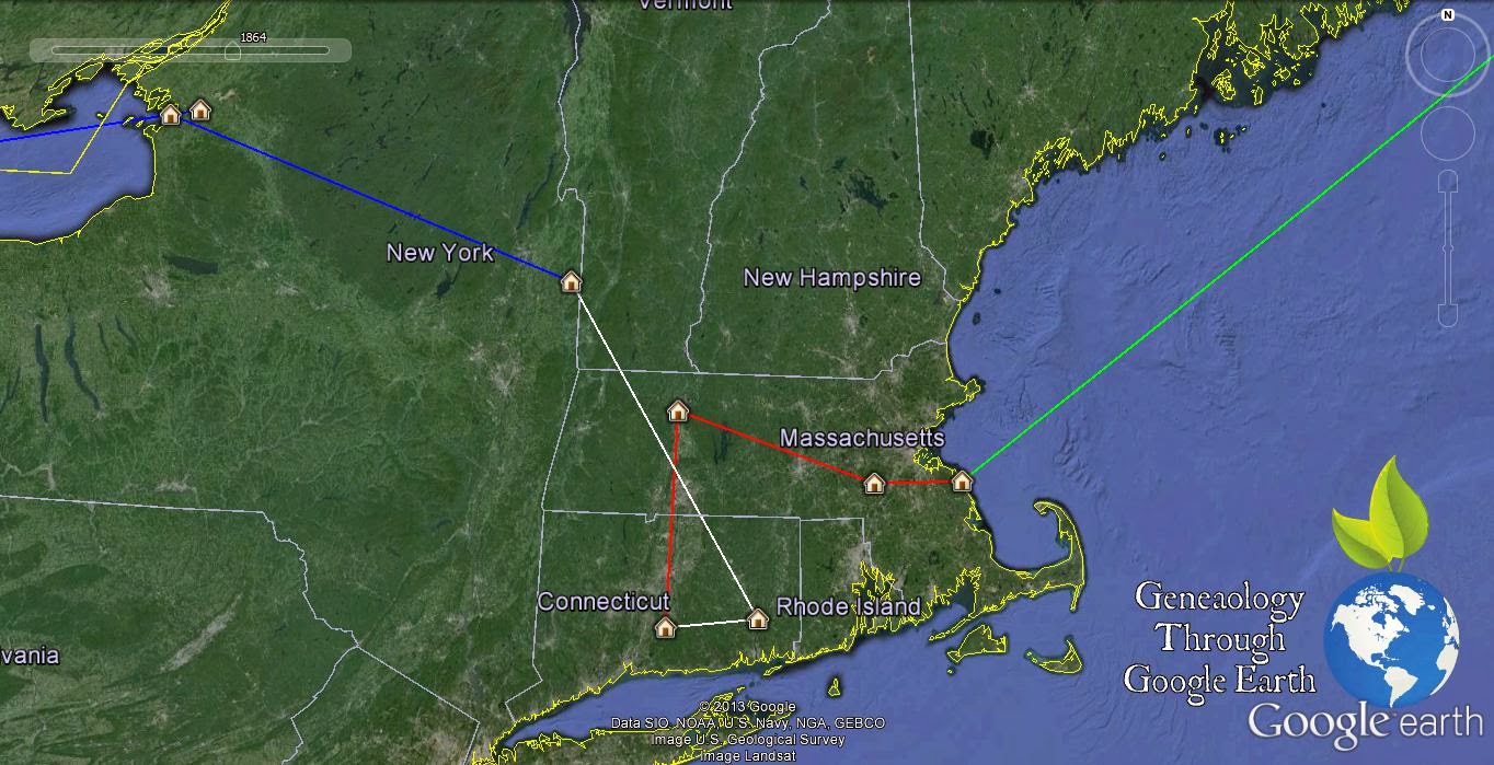
I have used placemarkers to document the final resting place of all my family.  Any time I am going to a cemetery I have my cell phone with me, this is important for my Google Earth research.  My iPhone has a camera and GPS.  The GPS that is on the phone isn't the most accurate but neither is Google Earth.  The iPhone GPS is only accurate to about 16 feet.  When we are talking about finding a grave 16ft is not much to work with but its worlds better then trying to rely on Rows and Section, especially if the cemetery is old and the marker stones have sunk or disappeared.

My Cemetery Project has me tracking down family members in 31 cemeteries.  That is just the cemeteries I have personally visited.  I also use Google Earth to track all my cemeteries I want to visit and who in that cemetery I am looking for, I have 44 cemeteries and counting to go visit someday. I don't use placemarkers for the cemeteries I want to visit and I will go over how and why in a future post. Using placemarkers to track my family is just the surface. The placemarkers default is a yellow pushpin, I didn't think this really represented my relatives well. So what I did was not only changed the icon but the color too.  I choose between two icons ones with dots in them and ones without, this would identify direct descendants and other family members. Then I changed the color, I just picked a color scheme that worked for me, trying to stick with basic colors to simplify things, this color scheme identified generations. I have see where someone mapped out a cemeteries and color coded the whole cemetery by gender. I have also thought about redoing mine to follow a more complex color schemes to divide my family placemarkers into paternal and maternal but haven't yet because of the size of my project as it stands now.

That's just the Icon, now the Name/Title for the placemarker. Mine is really simple its just a number based on when I put them in that cemetery. I restart my number each cemetery, this is so when I print a cemetery map I can use this numbering system to identify the who. It also is small image, so if your family members are laid next to each other in the cemetery the text image for that placemarker isn't covering up other relatives, while its not a big deal in Google Earth it would be a problem in printing. With the Icon and Name out of the way its time to get creative and share your family members memory, and you do that in the Description box. Here is where your placemarker can really start coming alive. You can just make a simple comment of who this marker represents and a birth to death date, but you can also take it so much further. I have added pictures of that relative if I have one or since its a cemetery I post a photo of their tombstones. I also put links to their FindAGrave.com memorial, which is a good link to have to share a obituary or biography if you don't want to place those in your placemarker. This helps make your Google Earth more interesting to whoever you are sharing it with.

The last thing I have been doing with my cemetery placemarkers is adding a time stamp to them. This adds an interesting feature to the project as you see how and when they populated the cemetery. Its a new feature I have been adding to my project so not all of my cemetery placemarkers have had this rewritten into the placemarker but definitely a must if you are starting out, especially if you have lots a family members in one cemetery.

After I get through this show and tell I will explain in detail how I designed the placemarkers in a later post. I am creating templates that you will beable to download. My next post will be Polygon and plotting family land in Google Earth.

Thursday, January 2, 2014

Why use Google Earth for Genealogy???

Genealogy Through Google Earth                       by Eric Stitt


We all know that Genealogy and Family research doesn't always happen in your back yard.  We can’t just get in the car and drive across the states to visit the old homestead, and I know I’ll be camped out in line when we figure out time travel.  But what if you could visit that old homestead or scroll back in time when your neighborhood was an old farm field, Google Earth can do that. 

Using geographic information found in Deeds and addresses from sources such as Census data, property where ancestors and neighbors once lived may be marked on historical maps, which can then be overlaid on modern Google maps. Geographic features mentioned in property descriptions such as rivers and creeks will appear on topographical maps and in Google’s satellite imagery. Using this information, it is possible to locate a family homestead on an historical map and compare the changes to those locations that have occurred over time as the area developed. In some instances, the old home may still be there or a family cemetery.

How many times have you found a source that quotes your family member is buried in Sec D, Row 12, Lot 52 and then turn around and still have to hunt through 100’s of tombstones just to find them?  In Google Earth we can make place markers to pin point your family member with GPS, and then you can print out a map for other family members to use next Memorial Day.

In Google Earth for Genealogy you can learn to do all these things.  Making your family stories really come to life with 3D models and giving your family a God's eye view of your families history.  

Check out www.earth.google.com/ to download Google Earth for yourself.

Wednesday, January 1, 2014

A New World of Family History Research

Hello everyone and welcome to my new blog Genealogy though Google Earth. I have been using Google Earth for my Genealogy from the beginning, and teaching a Google Earth for Genealogy Classes up in St Joseph MO for the Northwest Missouri Genealogical Society for a few years now. Just recently I was asked to present at the GenealogyKC Conference this spring and between the two thought I should start a blog dedicated to Google Earth and Genealogy.

My plan is start out describing how I use Google Earth in my family history and then move towards sharing more advanced features. All that being said it is going to take some time to write each post, in the mean while I still plan on writing on my original blog.  I all ready have some posts Google Earth related over at my other blog Genealogy by Eric and below are links to the individual posts.


You can get a head start by downloading Google Earth at http://www.google.com/earth/.  So stay tuned as I help you explore the world of your ancestors with Google Earth.